[:it]
Obiettivi
Il WP è sviluppato in due sotto-azioni:
4.1) Modellazione dei crolli a scala regionale. La prima parte del WP è incentrata sulla raccolta delle carte tematiche (geologia, uso del suolo, geologia superficiale, elementi a rischio, misure difensive esistenti) necessarie per la simulazione di crolli. Il passo successivo è l’identificazione e la caratterizzazione delle aree d’innesco, per produrre una mappa delle aree sorgenti di frana in Regione Lombardia e la simulazione di diversi scenari di volume per ciascuna area sorgente, attraverso l’utilizzo il codice HY-STONE.
4.2) Studio della pericolosità. La seconda parte del WP è incentrata sullo sviluppo di curve di pericolosità per ogni cella della griglia del modello di elevazione digitale, utilizzato per la simulazione e lo sviluppo della mappa di pericolosità. Il passo successivo sarà l’intersezione della mappa di pericolosità con gli elementi a rischio, al fine di produrre una mappa dei rischi.
Risultati
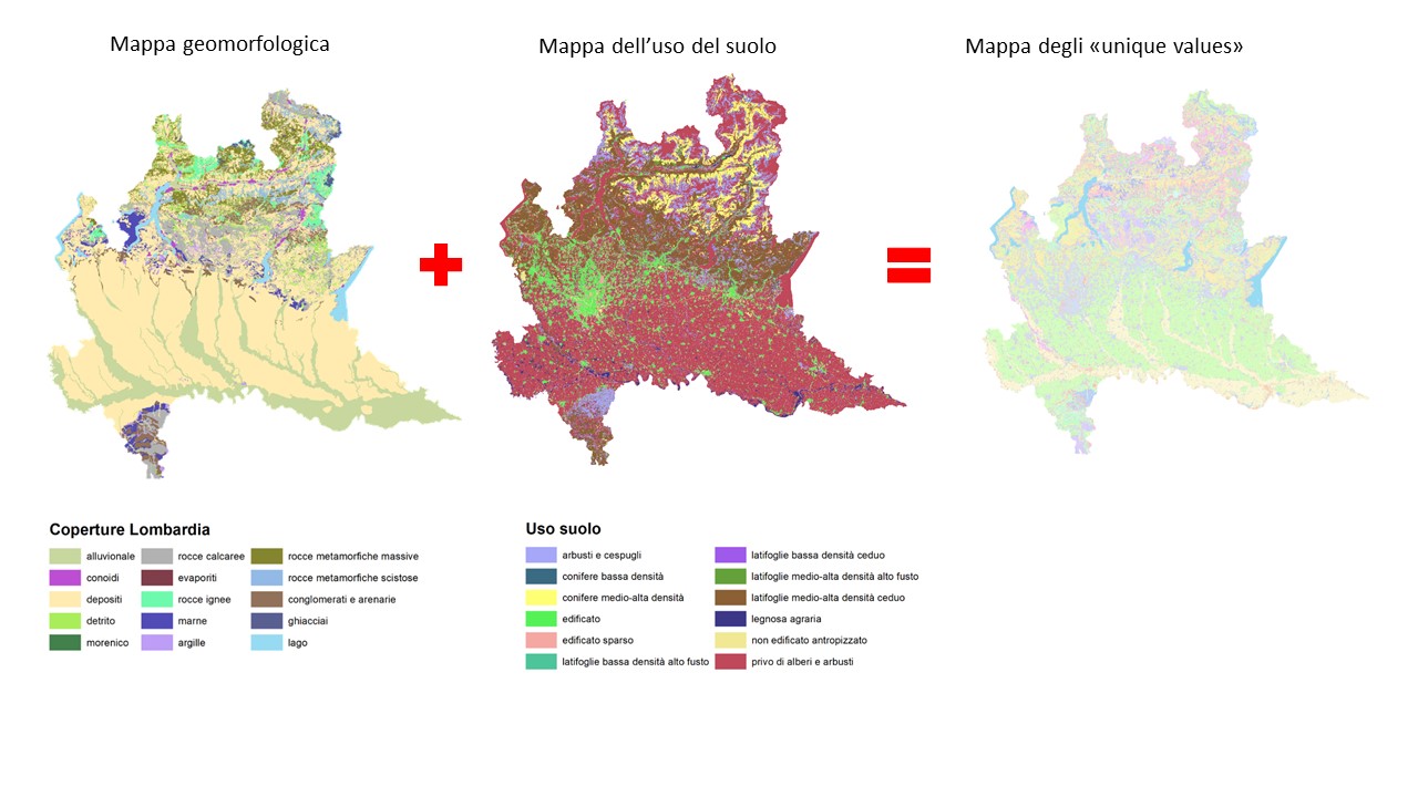
La mappa dell’uso del suolo e geoambientale della Lombardia, rese disponibili dalla Regione, sono state riclassificate in unità di terreno omogenee ai fini della modellazione della caduta massi con il software HY-STONE. Dall’unione delle due mappe è stata creata una nuova mappa per l’intera Lombardia, che raccogliesse al suo interno delle aree di “unique values” con un’informazione sia delle caratteristiche geomorfologiche e di uso del suolo.
 Le sorgenti di crollo sono state definite secondo criteri di pendenza e attraverso l’utilizzo di mappe litologiche per affioramenti sub-affioranti e affioranti. I parametri di modellazione sono stati definiti attraverso la calibrazione di eventi inseriti nel database del WP1 tramite il software HY-STONE.
In particolare, sono state simulate 26 frane di crollo in diversi contesti litologici e di uso del suolo. Queste frane sono in parte del database IFFI ed in parte eventi storici mappati sul terreno (es: Fiumelatte, Cataeggio). Per ogni frana, è stato calibrato il modello per fittare l’espandimento e la distribuzione dei blocchi arrestati.
I parametri calibrati di ogni simulazione sono stati poi analizzati statisticamente per ottenere valori medi da applicare al modello regionale.
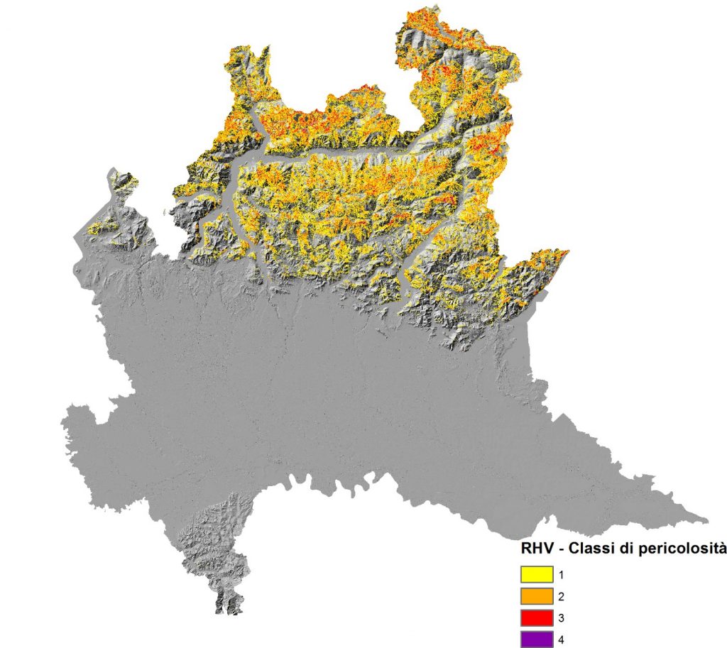
Dai risultati di modellazione caduta massi è stata creata una mappa di pericolosità secondo il metodo del RHV (Crosta e Agliardi, 2003), tramite il quale sono state individuate 4 classi di pericolosità (1 bassa pericolosità, 4 alta pericolosità) per l’intera Regione Lombardia.

Dallo studio e dalla modellazione di caduta massi è emerso che:
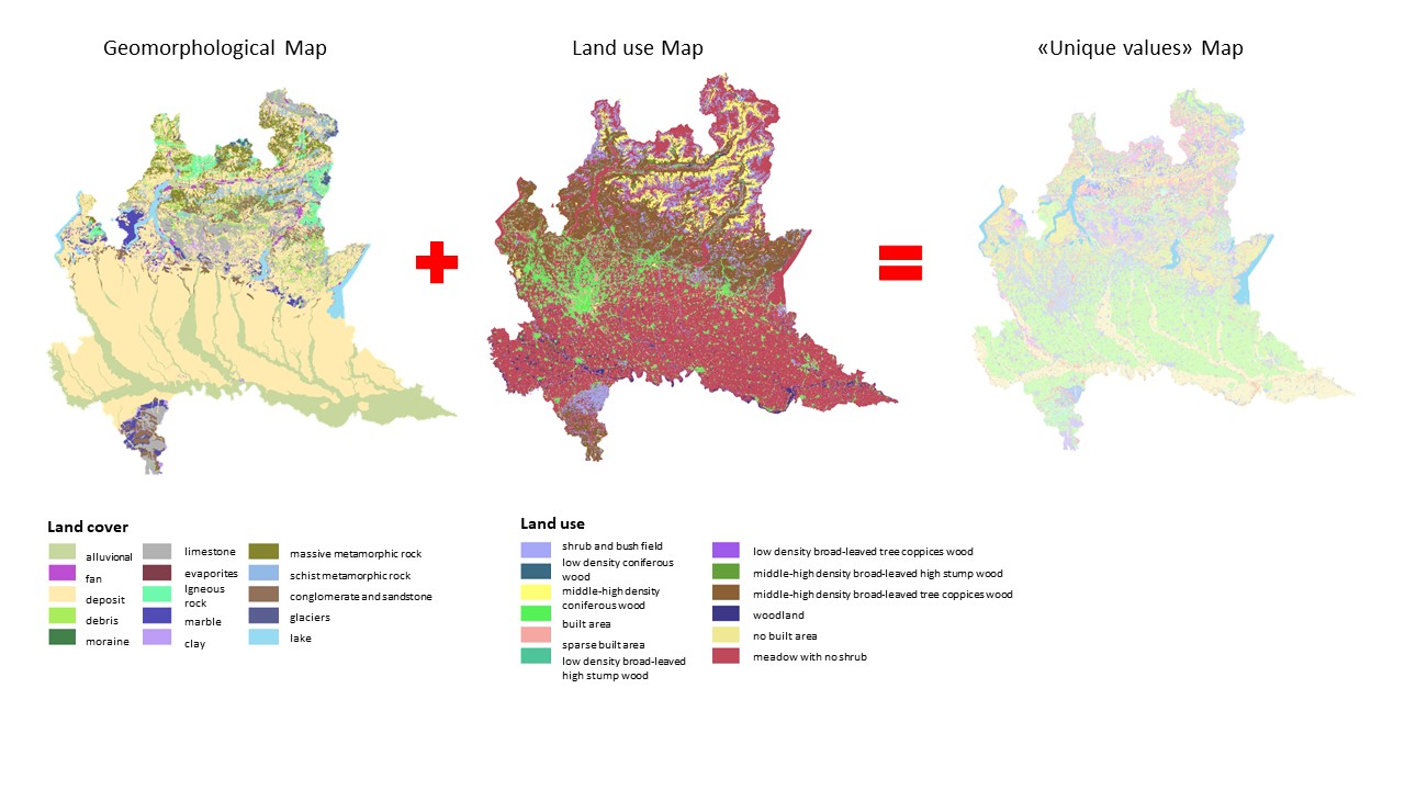
- In Lombardia le aree potenzialmente sorgenti di crollo sono292 km², pari al 5,4% territorio regionale.
- La superficie interessata dalla propagazione di blocchi è di 3.224 km², pari al 13,5% territorio lombardo

Analisi degli elementi a rischio:
- 840 edifici su 1.761.815 totali
- 478 km di strade su 60.268 km
- 17 km di linee ferroviarie su 740 km
[:en]
Objectives
The WP will be developed in two sub-actions:
4.1) Modeling of rockfall on a regional scale. The first part of the WP is focused on the collection and mapping of thematic layers needed for rockfall simulation (geology, land use, superficial geology, element at risk, existing defensive measures). The next step is the identification and characterization of source areas to produce a map of rockfall source areas in Regione Lombardia and the simulation of different volume scenarios from each source area by using the HY-STONE.
4.2) Hazard study. The second part of the WP is focused on the development of the regional hazard map. The next step will be the intersection of the hazard map with the elements at risk, in order to produce a risk map.
Results
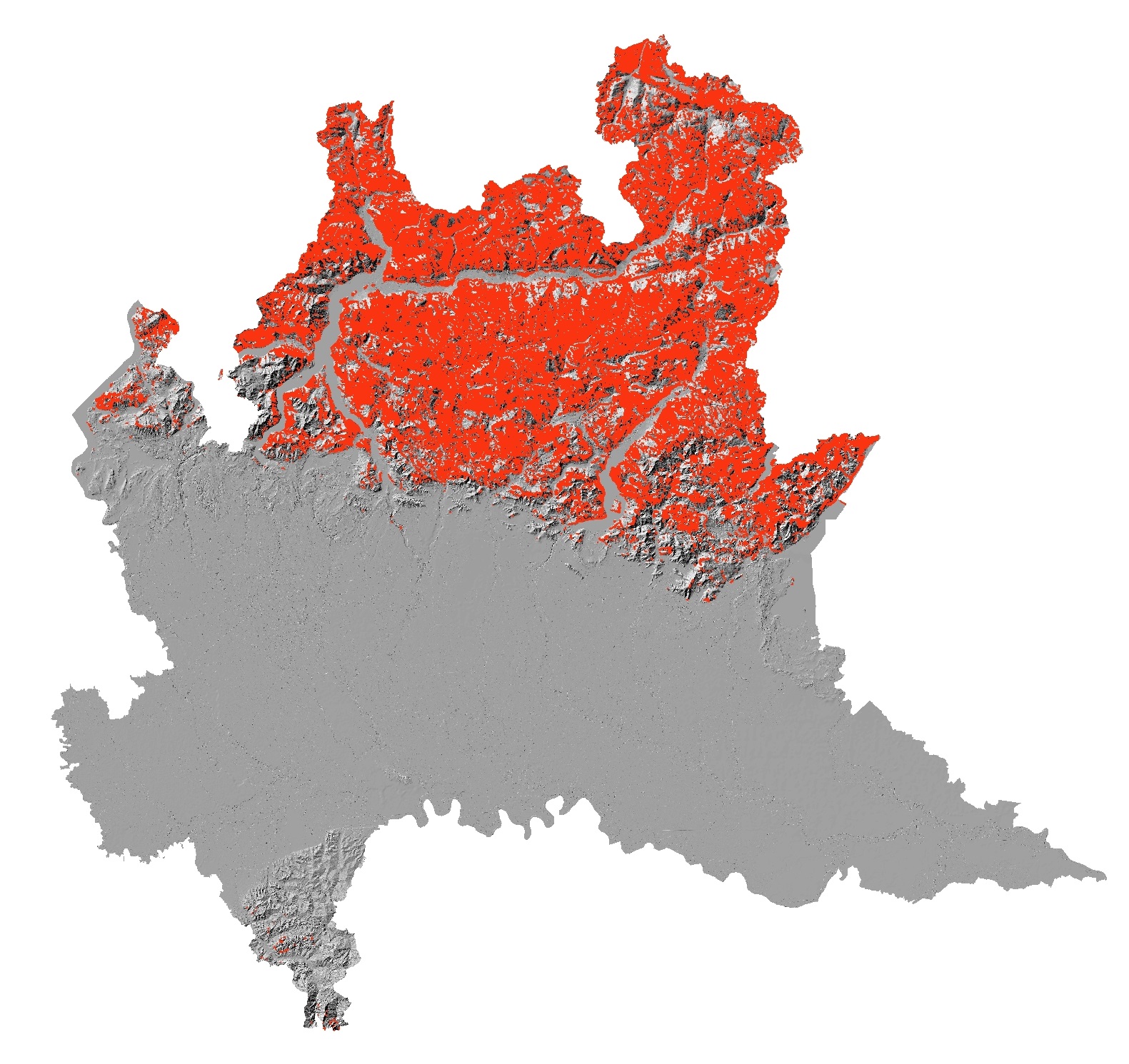
The land use and geomorphological map of Lombardy, available by the Region, has been reclassified into homogeneous land units for the purposes of rockfall modeling with the HY-STONE software. From the union of the two maps a new map was created for the whole of Lombardy, which gathered within it areas of “unique values” with information on both the geomorphological characteristics and land use.
The collapse sources have been defined according to slope criteria and through the use of lithological maps for sub-outcrop and outcropping bodies. The modeling parameters were defined by calibrating events inserted in the WP1 database using the HY-STONE software.
26 landslides were simulated in different lithological and land use contexts. These landslides are partly of the IFFI database and partly of historical events mapped on the ground (eg: Fiumelatte, Cataeggio). For each landslide, the model is calibrated to cover the expansion and distribution of the blocks stopped. The calibrated parameters of each simulation are then analyzed statistically to obtain average values to be applied to the regional model.
The results of rockfall modeling were implemented to create an Hazard map according to the RHV method (Crosta and Agliardi, 2003). The region is than subdivided in 4 hazard classes (1 low hazard, 4 high hazard).
On going research
The hazard map will be the intersec with the elements at risk (buildings, streets, railway line), in order to produce a risk map.
[:]